SPC Day 1 Fire Weather Outlook

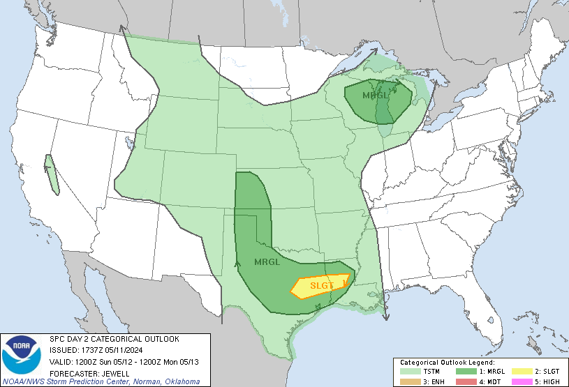
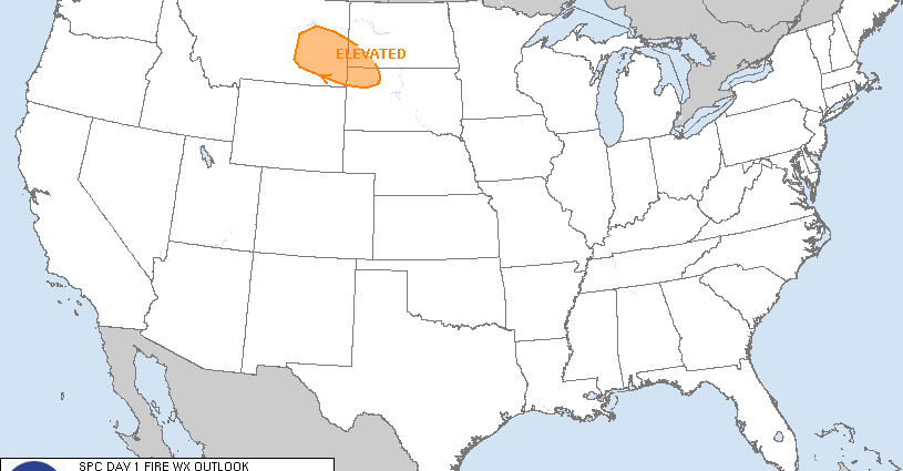
Day 1 Fire Weather Outlook  
NWS Storm Prediction Center Norman OK
0148 AM CDT Thu Apr 18 2024

Valid 181200Z - 191200Z

...NO CRITICAL AREAS...

...Synopsis...
Zonal mid-level flow is expected over much of the US as a broad
low-amplitude trough moves over the central CONUS. Weak ridging is
expected farther south which will force stronger flow aloft to
remain displaced over the northern third of the country. At the
surface, a low will move eastward with the broad trough while a cold
front moves south over much of the Plains. Much cooler temperatures,
higher humidity, and weaker winds are expected within the
post-frontal air mass. The only exception to this may be across far
northeast NM and southern CO where the air mass is expected to
remain drier and could support a few hours of locally elevated
fire-weather concerns. Otherwise, fire-weather concerns appear
unlikely over much of the CONUS today.

..Lyons.. 04/18/2024

...Please see www.spc.noaa.gov/fire for graphic product...

Read more

SPC Day 2 Fire Weather Outlook

Day 2 Fire Weather Outlook  
NWS Storm Prediction Center Norman OK
0151 AM CDT Thu Apr 18 2024

Valid 191200Z - 201200Z

...NO CRITICAL AREAS...

...Synopsis...
Generally zonal flow will continue over the US ahead of a subtle
southern stream trough over northern Mexico. At the surface, a
back-door cold front will move into the southern high Plains and
Rockies as high pressure intensifies over the central CONUS. With
upslope trajectories, cooler temperatures, and weak winds, little
overlap of dry and breezy conditions is expected over the southern
High Plains. Fire-weather concerns should remain low for most areas.
Portions of the Southwest and southern Great Basin are expected to
generally remain dry. But, at present, fuels are not receptive and
winds are forecast to remain modest limiting the potential for
fire-weather concerns.

..Lyons.. 04/18/2024

...Please see www.spc.noaa.gov/fire for graphic product...

Read more

SPC 1200Z Day 1 Outlook

Day 1 Outlook Image

Day 1 Convective Outlook  
NWS Storm Prediction Center Norman OK
1255 AM CDT Thu Apr 18 2024

Valid 181200Z - 191200Z

...THERE IS AN ENHANCED RISK OF SEVERE THUNDERSTORMS ACROSS PART OF
THE OZARKS...MID MISSISSIPPI VALLEY...AND LOWER OHIO VALLEY...

...SUMMARY...
A line of strong to severe storms will impact the Ozarks, mid
Mississippi Valley and lower Ohio Valley this afternoon and evening,
with wind damage, isolated large hail and a few tornadoes. Scattered
to widely-scattered storms with a large hail and wind-damage threat
will also be likely in parts of the Ark-La-Tex and southern Plains.

...Ozarks/Mid Mississippi Valley/Lower Ohio Valley...
An upper-level trough, and an associated mid-level jet, will move
through the north-central U.S. today. At the surface, a low will
move through Missouri as a cold front advances east-southeastward
into the Ozarks. Ahead of the front, the moist sector will be in
place by late morning across much of southern and central Missouri
extending eastward into the Mid Mississippi Valley. Surface heating
and enhanced low-level convergence ahead of the front will lead to a
gradual intensification of convection during the morning in western
Missouri. Scattered storms will eventually organize into a line,
moving eastward from the Ozarks into the mid Mississippi Valley
during the mid to late afternoon.

Ahead of the front, a moderately unstable airmass will be in place
by midday, with MLCAPE reaching the 1500 to 2500 J/kg range over
much of the moist sector. Forecast soundings near the instability
axis this afternoon suggest that 0-6 km shear will generally be in
the 35 to 40 knot range. This should be sufficient for supercell
development early in the event when cells are more likely to be
discrete. Large hail will be possible with supercells. Convective
development will be driven by low-level convergence, and this should
result in linear development as convective coverage increases in the
early to mid afternoon. Wind damage will become likely as a nearly
continuous line of storms develops. Although low-level shear is not
forecast to be that strong, a few QLCS tornadoes will be possible
with rotating cells embedded within the line. The severe threat will
likely continue into the evening, as the line cross the Mississippi
River and moves through the lower Ohio Valley.

...Ark-La-Tex/Southern Plains...
A shortwave trough will move through the Ark-La-Tex today, as a cold
front advances southeastward across the southern Plains. Ahead of
the front, surface dewpoints in the upper 60s and lower 70s F will
contribute to moderate to strong instability across much of the
moist sector by afternoon. Surface heating and increasing low-level
convergence ahead of the front will lead to the development of
isolated to scattered thunderstorms. Several clusters of storms are
expected to move across the warm sector during the late afternoon
and early evening.

RAP forecast soundings by mid afternoon from the Texas Hill Country
into north-central Texas have MLCAPE reaching the 2500 to 3500 J/kg
range. 0-6km shear is forecast to be in the 35 to 40 knot range with
700-500 mb lapse rates near 8.0 C/km. This environment will likely
support supercells with isolated large hail. Hailstones greater than
2 inches in diameter will be possible with the more intense and
dominant supercells. A wind-damage threat is also expected to
develop. Storm coverage in many areas will remain isolated due to a
weak capping inversion that is evident above 850 mb on many forecast
soundings.

..Broyles/Lyons.. 04/18/2024

Read more

SPC 0600Z Day 2 Outlook

Day 2 Outlook Image

Day 2 Convective Outlook  
NWS Storm Prediction Center Norman OK
1154 PM CDT Wed Apr 17 2024

Valid 191200Z - 201200Z

...THERE IS A MARGINAL RISK OF SEVERE THUNDERSTORMS OVER PARTS OF
THE SOUTHEAST...

...SUMMARY...
Sporadic strong to marginally severe storms are possible on Friday
over parts of the Southeast.

...Synopsis and Discussion...
An upper low will deepen as it moves across Ontario, with strong
flow across the Great Lakes with a 90+ kt, elongated midlevel speed
max. Well to the south, 30-40 kt midlevel winds will exist across
northern portions of MS/AL/GA/Carolinas. This flow will be
juxtaposed with a destabilizing air mass ahead of a cold front, with
MLCAPE over 1000 J/kg developing where heating is strongest.

Storms are likely to develop over the Appalachians, extending
southwestward along the front into northern GA, AL, and into central
MS. A subsidence inversion below 700 mb will be a concern for the
lower elevations, but at least isolated marginally severe storms
will be possible coincident with peak heating and with sufficient
frontal convergence.

Forecast soundings show steep low-level lapse rates but relatively
weak low-level winds. However, modest west/northwest flow aloft and
sufficiently long hodographs may favor a few cells capable of
marginal hail and locally damaging gusts.

..Jewell.. 04/18/2024

Read more

SPC 0730Z Day 3 Outlook

Day 3 Outlook Image

Day 3 Convective Outlook  
NWS Storm Prediction Center Norman OK
0145 AM CDT Thu Apr 18 2024

Valid 201200Z - 211200Z

...NO SEVERE THUNDERSTORM AREAS FORECAST...

...SUMMARY...
Severe storms are not currently forecast on Saturday. A few strong
storms cannot be ruled out over parts of the Southeast, and over
parts of Texas.

...Synopsis and Discussion...
On Saturday, a large upper trough will move quickly east across the
Great Lakes and Northeast, while an upper low deepens over Hudson
Bay. A relatively wide zone of moderate midlevel westerlies will
remain south of these entities, from the central Plains to the East
Coast. Elsewhere, a southern-stream wave will move into the southern
Plains, providing cooling aloft.

At the surface,  a weak area of low pressure may linger over SC,
with a front extending westward into southern TX during the day.
This front will slowly shift south, reaching the western Gulf of
Mexico by Sunday morning.  A moist air mass will remain ahead of the
front, resulting in elevated instability over the southern Plains,
and areas of surface-based instability over the Southeast.

The strongest pocket of instability may exist from GA into SC
coincident with steeper low-level lapse rates. Given relatively week
shear, severe storms are not currently forecast. However, a few
strong storms will be possible assuming antecedent convection has
not pushed the effective boundary offshore prior to peak heating.

Over TX and OK, models indicate substantial elevated CAPE will
exist, but also widespread clouds, rain and thunderstorms throughout
the period. A few storms could potentially support marginal hail,
however, predictability is a bit low given expected widespread
precipitation.

..Jewell.. 04/18/2024

Read more

Fair
Winds are from the West at 10.4 gusting to 18.4 MPH (9 gusting to 16 KT). The pressure is 1015.2 mb and the humidity is 63%.
The wind chill is 56.
Last Updated on Apr 18 2024, 1:55 am EDT.
Winds are from the West at 10.4 gusting to 18.4 MPH (9 gusting to 16 KT). The pressure is 1015.2 mb and the humidity is 63%.
The wind chill is 56.
Last Updated on Apr 18 2024, 1:55 am EDT.