 Skip to content


SPC MD 497
2024-04-19
SPC Mesoscale Discussions
MD 0497 CONCERNING SEVERE POTENTIAL…WATCH UNLIKELY FOR PORTIONS OF FAR EAST-CENTRAL MS…NORTHERN/CENTRAL AL…AND NORTHERN GA
Mesoscale Discussion 0497
NWS Storm Prediction Center Norman OK
0454 PM CDT Fri Apr 19 2024

Areas affected...Portions of far east-central MS...northern/central
AL...and northern GA

Concerning...Severe potential...Watch unlikely

Valid 192154Z - 192330Z

Probability of Watch Issuance...5 percent

SUMMARY...A couple loosely organized storms capable of marginally
severe hail and locally damaging gusts are possible for the next
couple hours. Watch not expected.

DISCUSSION...Isolated thunderstorms are developing across portions
of northern AL this afternoon, ahead of an outflow-augmented cold
front draped across the region. Attempts at convective initiation
are also evident over far east-central MS and northern GA.
Antecedent heating/destabilization of a moist boundary layer (upper
60s/lower 70s dewpoints) has yielded moderate surface-based
instability ahead of the front. This may support a couple loosely
organized multicells and transient supercell structures, given 30-35
kt of effective shear -- characterized by a mostly straight
hodograph (with weak low-level shear). Therefore, marginally severe
hail (near 1 inch in diameter) and locally damaging gusts cannot be
ruled out with any robust/sustained cores during the next couple
hours, before the onset of nocturnal cooling/stabilization. Weak
synoptic and mesoscale ascent should keep the severe risk localized,
and a watch is not expected.

..Weinman/Guyer.. 04/19/2024

...Please see www.spc.noaa.gov for graphic product...

ATTN...WFO...GSP...FFC...BMX...HUN...MEG...JAN...

LAT...LON   33938810 34738544 34948442 34928373 34698342 34288342
            33948386 33478492 32958697 32778803 32878856 33118886
            33458893 33698866 33938810
https://www.spc.noaa.gov/products/md/md0497.htmlSPC Mesoscale Discussions

Partly Cloudy and 61 F at Dayton / Wright-Patterson Air Force Base, OH
2024-04-19

Winds are from the Northwest at 15.0 gusting to 20.7 MPH (13 gusting to 18 KT). The pressure is 1018.1 mb and the humidity is 48%.
The wind chill is 59.
Last Updated on Apr 19 2024, 2:55 pm EDT.
Winds are from the Northwest at 15.0 gusting to 20.7 MPH (13 gusting to 18 KT). The pressure is 1018.1 mb and the humidity is 48%.
The wind chill is 59.
Last Updated on Apr 19 2024, 2:55 pm EDT.
The wind chill is 59.
Last Updated on Apr 19 2024, 2:55 pm EDT.
SPC Day 1 Fire Weather Outlook
2024-04-19
SPC Day 1 Fire Weather Outlook
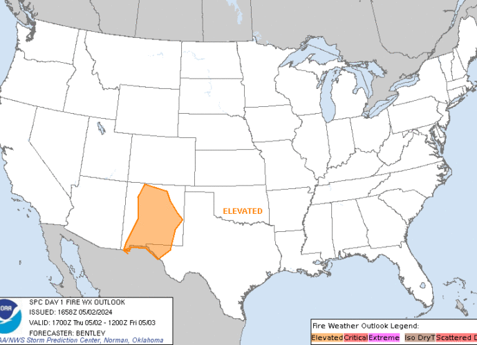
Day 1 Fire Weather Outlook
NWS Storm Prediction Center Norman OK
1022 AM CDT Fri Apr 19 2024

Valid 191700Z - 201200Z

...NO CRITICAL AREAS...

The previous forecast (see below) remains on track, with no changes
or additions made.

..Squitieri.. 04/19/2024

.PREV DISCUSSION... /ISSUED 0123 AM CDT Fri Apr 19 2024/

...Synopsis...
A weak/low-amplitude southern-stream trough will track eastward
across the Southwest, encouraging breezy/gusty southwesterly winds
amid a dry/deeply mixed boundary layer across the region. While
elevated meteorological conditions are likely across portions of
eastern AZ and western NM during the afternoon, marginal fuels
should keep the fire-weather threat fairly localized -- precluding
highlights at this time. Elsewhere across the CONUS, a limited
overlap of warm/dry/breezy conditions will limit fire-weather
concerns.

...Please see www.spc.noaa.gov/fire for graphic product...

SPC Day 2 Fire Weather Outlook
2024-04-19
SPC Day 2 Fire Weather Outlook
Day 2 Fire Weather Outlook
NWS Storm Prediction Center Norman OK
0210 PM CDT Fri Apr 19 2024

Valid 201200Z - 211200Z

...NO CRITICAL AREAS...

The previous forecast (see below) remains unchanged.

..Squitieri.. 04/19/2024

.PREV DISCUSSION... /ISSUED 0124 AM CDT Fri Apr 19 2024/

...Synopsis...
An expansive post-frontal air mass, characterized by cool surface
temperatures and weak surface winds, will encompass much of the
central and eastern CONUS, limiting fire-weather concerns. Dry
conditions will persist over the Southwest, though weak surface
winds and marginal fuels will also limit fire-weather potential
here.

...Please see www.spc.noaa.gov/fire for graphic product...
SPC Apr 19, 2024 1630 UTC Day 1 Convective Outlook
2024-04-19
SPC 1630Z Day 1 Outlook
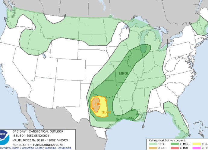
Day 1 Convective Outlook
NWS Storm Prediction Center Norman OK
1126 AM CDT Fri Apr 19 2024

Valid 191630Z - 201200Z

...THERE IS A MARGINAL RISK OF SEVERE THUNDERSTORMS FOR PARTS OF THE
SOUTHEAST...

...SUMMARY...
Sporadic strong to marginally severe storms are possible over parts
of the Southeast this afternoon into the early evening.

...Southeast this afternoon/evening...
Late morning water-vapor imagery shows a mid-level shortwave trough
moving east across the southern Appalachians.  This feature will
reach the VA/NC coast early tonight.  Farther northwest, a closed
midlevel low will evolve into an open wave as it moves eastward over
the Great Lakes and OH Valley.  An associated surface cold front
will continue to move slowly southeastward from TX to the southern
Appalachians.  Isolated to widely scattered thunderstorms will be
possible with the disturbance over the Carolinas this afternoon.
Other than the front pushing into portions of AL/GA, little
larger-scale forcing for ascent is expected farther southwest.
Additional storm development will be associated with the front and
orographic lift along the spine of the Appalachians.  Overall
weak-moderate buoyancy, modest deep-layer shear and steepening
low-level lapse rates will support some potential semi-organized
storms capable of producing isolated wind damage and marginally
severe hail for a few hours this afternoon/evening.

...TX through tonight...
--No change needed to previous forecast discussion--
Weak upslope flow along a slow moving cold front will favor
thunderstorm development over the east slopes of the Sierra Madre
Oriental/Sierra del Burro this afternoon, with the potential for a
couple of supercells.  However, it is not clear that storm motions
will bring the convection across the Rio Grande, and lingering
convective inhibition suggests storms will likely weaken if they
manage to cross the border.  Later tonight in northwest TX, elevated
convection will likely develop atop the frontal surface, in a warm
advection regime downstream from a weak shortwave trough over AZ/NM.
Some small hail may occur given lingering steep midlevel lapse rates
and modest cloud-layer shear, but the potential for severe hail
appears too low to warrant an outlook area.

..Smith/Moore.. 04/19/2024
SPC Apr 19, 2024 1730 UTC Day 2 Convective Outlook
2024-04-19
SPC 1730Z Day 2 Outlook
Day 2 Convective Outlook
NWS Storm Prediction Center Norman OK
1152 AM CDT Fri Apr 19 2024

Valid 201200Z - 211200Z

...THERE IS A MARGINAL RISK OF SEVERE THUNDERSTORMS OVER MUCH OF
CENTRAL TEXAS AND FROM SOUTHERN ALABAMA ACROSS GEORGIA AND INTO
SOUTHERN SOUTH CAROLINA...

...SUMMARY...
Marginally severe storms capable of strong wind gusts and hail will
be possible on Saturday across much of central Texas, and during the
afternoon from southern Alabama across parts of Georgia and into
southern South Carolina.

...Synopsis...
An upper trough will move east from the Great Lakes into the
Northeast, as the parent upper low deepens over Hudson Bay. Moderate
westerly flow aloft will remain from the central Plains to the East
Coast, with a low-latitude wave moving from AZ/NM across the
southern Plains through Saturday night.

At the surface, high pressure will extend south and eastward across
much of the central and eastern CONUS, with a front from the coastal
Carolinas to the northern Gulf Coast and into southern TX. A moist
air mass will remain south of this boundary in TX, where lift north
of the boundary will lead to increase rain and thunderstorms.

...TX...
Primarily elevated thunderstorms are likely through much of the day
over parts of central and northern TX, with activity extending east
toward northern MS. This activity will be supported by modest warm
advection just above the cool post-frontal air mass. Instability may
still be substantial, especially just north of the surface front. As
such, a few hail reports will be possible over a relatively large
area, with a conditional risk of strong gusts closer to the front.

...Coastal SC into southern GA and AL...
The surface boundary will extend roughly from coastal SC across GA
and into southern AL during the afternoon, with strong heating
expected. Although gradual drying will occur due to westerly flow,
strong heating and sufficient moisture will still result in an
unstable air mass, and eastward-moving storms producing outflow are
anticipated. Given the steep low-level lapse rates, 1000-1500 SBCAPE
and sufficient deep-layer mean winds, isolated damaging gusts will
be possible.

..Jewell.. 04/19/2024