Overnight and Tomorrows forecast 4/ 24-25
Tonight – Widespread freeze. Low 28°F. Wind N, 3 to 7 mph.
Tomorrow 4-25 – Overcast, High 55°F. Wind NE, 5 to 15 mph.
Tomorrow night – Widespread frost, Low 34°F. Wind E, 5 to 7 mph.

SPC Apr 24, 2024 1300 UTC Day 1 Convective Outlook
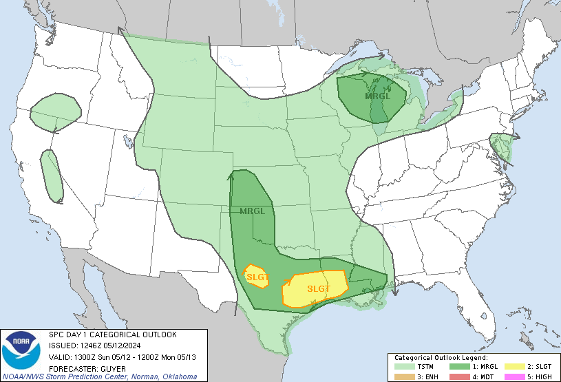
Day 1 Convective Outlook
NWS Storm Prediction Center Norman OK
0745 AM CDT Wed Apr 24 2024

Valid 241300Z - 251200Z

...THERE IS A SLIGHT RISK OF SEVERE THUNDERSTORMS THIS EVENING
ACROSS WEST CENTRAL TX...

...SUMMARY...
Isolated large hail and damaging winds will be possible this evening
across west central Texas.

...West central TX this evening...
A midlevel shortwave trough off the southern CA coast will move
inland over southern AZ by the end of the period.  Downstream,
shortwave ridging will persist over the Plains, though some increase
in westerly flow over the Rockies will contribute to lee troughing
across eastern CO/NM.  The lee trough will maintain southerly
low-level flow and a gradual increase in low-level moisture to the
south of a warm front that will move slowly northward across OK and
the TX Panhandle.  The moistening (boundary-layer dewpoints of 64-70
F and 100 mb mean mixing ratios of 12-14 g/kg) will occur beneath a
warm elevated mixed layer with midlevel lapse rates of 8-9 C/km,
which will drive large buoyancy (MLCAPE > 2000 J/kg) within a capped
warm sector.

The potential exception to this is along the developing dryline
across west central TX where surface heating/mixing could be deep
enough to remove convective inhibition, and isolated thunderstorm
development will be possible by this afternoon/evening.  Confidence
in storm development is modest, but the environment with large
buoyancy, steep lapse rates and effective bulk shear greater than 40
kt will conditionally favor supercells capable of producing isolated
very large hail up to 2.5 inches in diameter and severe outflow
gusts of 60-70 mph.  There will be an increase in low-level shear
this evening and low-level moisture will be greater compared to
yesterday, so an isolated tornado will also be possible in a narrow
time window this evening before inhibition increases and storms
weaken.

...OK into KS through tonight...
Elevated thunderstorms are ongoing over western OK in a zone of
low-midlevel warm advection and weak buoyancy likely rooted near 700
mb.  Some of this convection could persist today while spreading
eastward, with a low-end hail threat.  Additional elevated storms
are expected to form overnight from northeast OK into KS with
strengthening warm advection and increasing low-level moisture.  A
couple of storms could produce isolated large hail the last few
hours of the forecast period.

..Thompson/Kerr.. 04/24/2024
SPC Apr 24, 2024 Day 4-8 Severe Weather Outlook
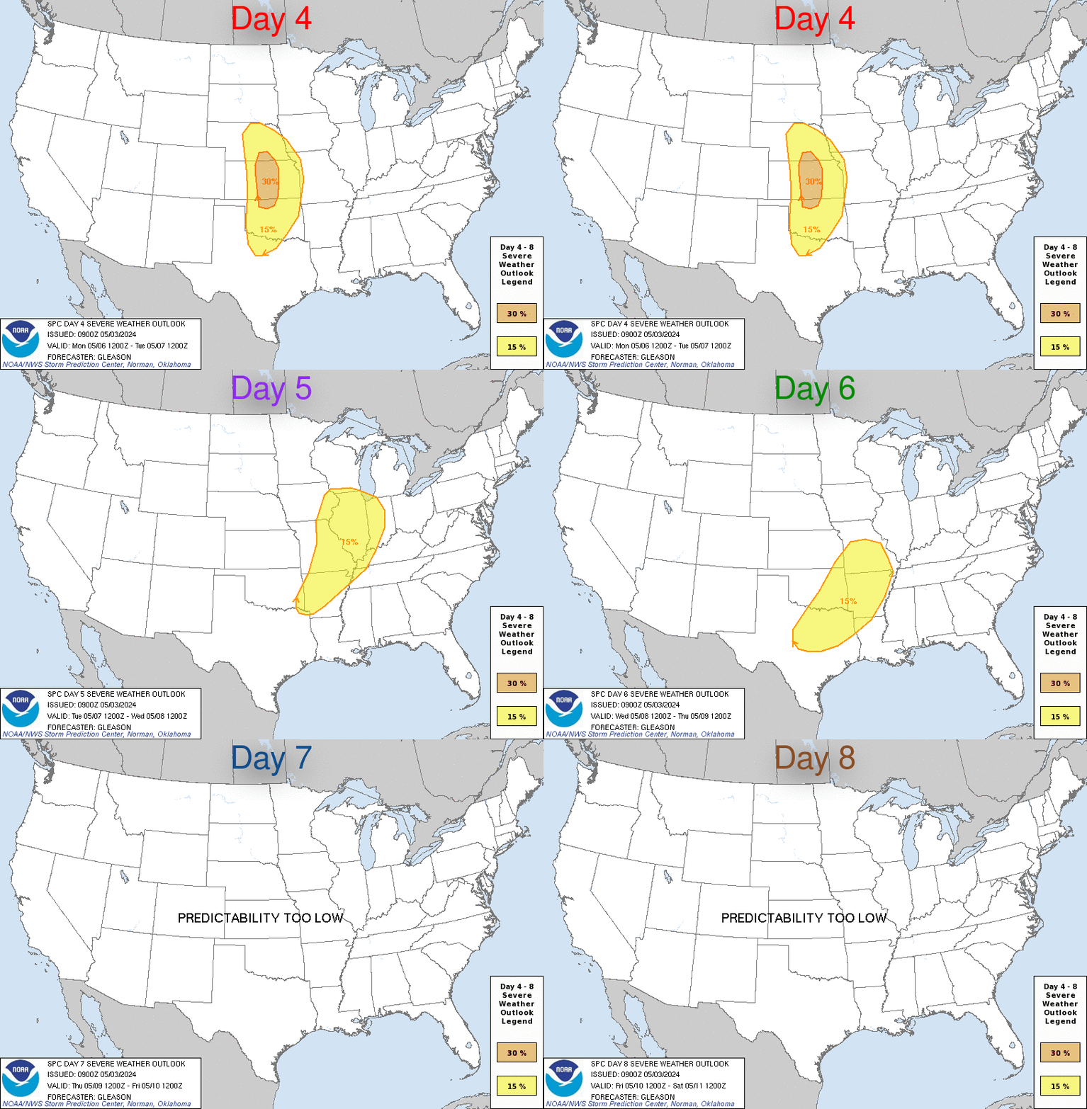
Day 4-8 Convective Outlook
NWS Storm Prediction Center Norman OK
0400 AM CDT Wed Apr 24 2024

Valid 271200Z - 021200Z

...DISCUSSION...
...D4/Saturday - Southern Plains into the upper Great Lakes...
An active severe thunderstorm episode appears possible on Saturday
across parts of the central and southern Plains, as a shortwave
trough and attendant strong mid/upper-level jet overspread a
generally warm and moist warm sector. A surface low is forecast to
deepen across southwest KS, with a dryline extending southward into
west TX. Thunderstorms are expected to develop near the dryline, and
potentially farther north/east within a moderate to strongly
unstable and weakly capped warm sector. Strong deep-layer shear will
support organized convection, including the potential for
supercells. There is some potential for rather early initiation and
evolution toward a complex convective mode with time, but any
supercells within this regime could become tornadic as low-level
shear/SRH notably increases during the afternoon/evening. A 30% area
has been added from south-central/southeast KS into OK and north TX,
where confidence is currently greatest regarding storm development
within the favorable environment described above.

A separate regime of severe potential could evolve from eastern IA
toward the upper Great Lakes, associated with the departing
shortwave trough and surface low. While this system will gradually
be weakening with time, storms could redevelop during the afternoon
within a moist and weakly capped environment, with deep-layer shear
remaining sufficiently strong for organized convection. Late in the
period, extensive convection that initially develops over the
central/southern Plains could also spread into parts of IA/IL/WI,
with some severe potential.

...D5/Sunday - ArkLaTex into the upper Midwest...
A corridor of organized severe potential could again evolve from the
ArkLaTex into the upper Midwest on D5/Sunday, as the strong
shortwave trough and attendant surface low move from the central
Plains towards the upper Great Lakes. Moderate instability and
favorable deep-layer shear could support a mix of supercells and
stronger storm clusters, though details remain uncertain at this
time.

...D6/Monday - ArkLaTex region into the lower MS Valley...
Some severe threat could linger into D6/Monday across the ArkLaTex
region into the lower MS Valley, as low-level moisture transport
persists near the remnant frontal zone. However, in the wake of the
departing upper trough, convection may tend to be less organized
compared to previous days.
Small Craft Advisory issued April 24 at 9:07AM EDT until April 24 at 8:00PM EDT by NWS Cleveland OH
LEZ144 The Islands to Vermilion OH* WHAT…North winds 10 to 20 knots and waves 3 to 5 feet.
* WHERE…The nearshore waters of Lake Erie from the Islands to
Conneaut OH.
* WHEN…Until 8 PM EDT this evening.
* IMPACTS…Conditions will be hazardous to small craft.https://api.weather.gov/alerts/urn:oid:2.49.0.1.840.0.03abad3e27d5631e780f3eb3d8ad96e789e105fa.002.1.cap9:08 amApril 24, 2024
Small Craft Advisory issued April 24 at 9:07AM EDT until April 24 at 8:00PM EDT by NWS Cleveland OH
LEZ143 Reno Beach to The Islands OH* WHAT…North winds 10 to 20 knots and waves 2 to 4 feet.
* WHERE…The nearshore waters of Lake Erie from Reno Beach to
The Islands OH.
* WHEN…Until 8 PM EDT this evening.
* IMPACTS…Conditions will be hazardous to small craft.https://api.weather.gov/alerts/urn:oid:2.49.0.1.840.0.03abad3e27d5631e780f3eb3d8ad96e789e105fa.001.1.cap9:08 amApril 24, 2024
SPC Apr 24, 2024 0730 UTC Day 3 Severe Thunderstorm Outlook

Day 3 Convective Outlook
NWS Storm Prediction Center Norman OK
0230 AM CDT Wed Apr 24 2024

Valid 261200Z - 271200Z

...THERE IS A SLIGHT RISK OF SEVERE THUNDERSTORMS FOR PARTS OF THE
CENTRAL/SOUTHERN GREAT PLAINS INTO THE MID MISSISSIPPI VALLEY AND
OZARKS...

...SUMMARY...
An active severe weather day appears possible on Friday from parts
of Nebraska and Iowa southward into parts of the southern Great
Plains and Ozarks. A few tornadoes, large to very large hail, and
damaging winds will all be possible.

...Synopsis...
A negatively tilted mid/upper-level shortwave trough and associated
occluding surface low are forecast to move northeastward toward the
upper Great Lakes from Friday into Friday night. A trailing Pacific
front/dryline will move eastward through the day across the
central/southern Plains, before retreating westward Friday night. A
warm front will move northward in advance of the surface low across
MO into parts of IA, though its progress may be slowed by convective
outflow resulting from extensive D2/Thursday convection.

...Central/southern Plains into the mid MS Valley...
A relatively active severe weather day appears possible from eastern
portions of the Great Plains into parts of the mid MS Valley and
Ozarks on Friday. However, uncertainty remains regarding the impact
of extensive antecedent convection on the quality of the warm
sector.

Thunderstorms that develop late on D2/Thursday may be ongoing during
the morning from eastern KS into central/eastern OK and north TX. At
least some severe threat may persist through the morning with this
convection, as it spreads into parts of MO/AR. With favorable
deep-layer shear across the warm sector, some intensification of
early convection will be possible during the afternoon, though there
may be a tendency for storms to move eastward out of the primary
instability axis. The strongest storms across eastern portions of
the warm sector could pose at least some threat for all severe
hazards, though magnitude of the threat remains uncertain.

With the dryline not expected to make a strong eastward push, some
redevelopment cannot be ruled out later in the day. Depending on
heating and destabilization trends, supercell development will be
possible from eastern NE/western IA southward into the ArkLaTex
region. Large hail (potentially in excess of 2 inches in diameter)
and could accompany any supercell development in this area, given
the persistence of rich low-level moisture beneath steep midlevel
lapse rates. Persistent moderate to strong low-level flow/shear will
also support tornado potential, especially if supercells can be
sustained near the ejecting shortwave and surface low across
northern portions of the risk area.

Southwestward extent of the severe threat during the
afternoon/evening remains uncertain. Development cannot be entirely
ruled out from central OK into north/central TX along the nearly
stalled dryline, though coverage would likely remain very isolated
in the wake of the departing shortwave trough.

..Dean.. 04/24/2024
