 Skip to content

Freeze Watch issued April 20 at 9:26AM EDT until April 21 at 8:00AM EDT by NWS Cleveland OH
Richland County (OHC139) OH* WHAT…Sub-freezing temperatures as low as 30 possible.
* WHERE…Portions of north central, northeast, and northwest Ohio.
* WHEN…From late tonight through Sunday morning.
* IMPACTS…Frost and freeze conditions could kill crops, other
sensitive vegetation and possibly damage unprotected outdoor
plumbing.https://api.weather.gov/alerts/urn:oid:2.49.0.1.840.0.8ae8f14fb3e473649528659315d90964cf2ca0d7.001.1.cap9:28 amApril 20, 2024
Freeze Watch issued April 20 at 9:26AM EDT until April 21 at 8:00AM EDT by NWS Cleveland OH
Huron County OHZ019 Ohio* WHAT…Sub-freezing temperatures as low as 30 possible.
* WHERE…Portions of north central, northeast, and northwest Ohio.
* WHEN…From late tonight through Sunday morning.
* IMPACTS…Frost and freeze conditions could kill crops, other
sensitive vegetation and possibly damage unprotected outdoor
plumbing.https://api.weather.gov/alerts/urn:oid:2.49.0.1.840.0.8ae8f14fb3e473649528659315d90964cf2ca0d7.001.1.cap9:28 amApril 20, 2024
Small Craft Advisory issued April 20 at 9:26AM EDT until April 20 at 1:00PM EDT by NWS Cleveland OH
LEZ144 The Islands to Vermilion OH* WHAT…West winds 15 to 20 knots and waves 2 to 4 feet.
* WHERE…The nearshore waters of Lake Erie from Reno Beach to
Vermilion OH.
* WHEN…Until 1 PM EDT this afternoon.
* IMPACTS…Conditions will be hazardous to small craft.https://api.weather.gov/alerts/urn:oid:2.49.0.1.840.0.7e49aaca733a659d05d568d553d7e75b6163c805.001.1.cap9:27 amApril 20, 2024
Small Craft Advisory issued April 20 at 9:26AM EDT until April 20 at 1:00PM EDT by NWS Cleveland OH
LEZ143 Reno Beach to The Islands OH* WHAT…West winds 15 to 20 knots and waves 2 to 4 feet.
* WHERE…The nearshore waters of Lake Erie from Reno Beach to
Vermilion OH.
* WHEN…Until 1 PM EDT this afternoon.
* IMPACTS…Conditions will be hazardous to small craft.https://api.weather.gov/alerts/urn:oid:2.49.0.1.840.0.7e49aaca733a659d05d568d553d7e75b6163c805.001.1.cap9:27 amApril 20, 2024

SPC Day 1 Fire Weather Outlook
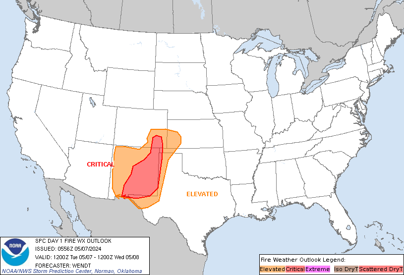
Day 1 Fire Weather Outlook
NWS Storm Prediction Center Norman OK
0154 AM CDT Sat Apr 20 2024

Valid 201200Z - 211200Z

...NO CRITICAL AREAS...

...Synopsis...
Fire-weather concerns should be minimal today, as an expansive
post-frontal air mass encompasses much of the central and eastern
CONUS. Warm/dry conditions will persist over the Southwest, though
generally weak surface winds (outside of local terrain enhancements)
and marginal fuels should limit large-fire potential.

..Weinman.. 04/20/2024

...Please see www.spc.noaa.gov/fire for graphic product...

SPC Day 2 Fire Weather Outlook
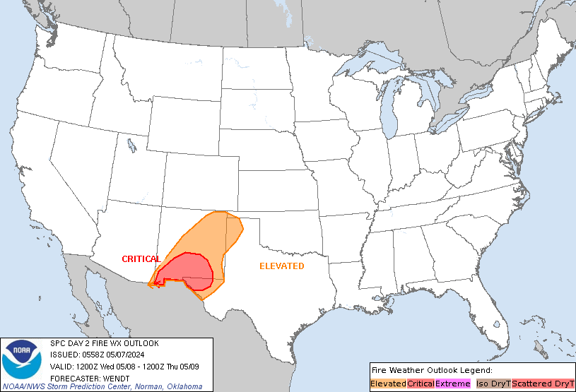
Day 2 Fire Weather Outlook
NWS Storm Prediction Center Norman OK
0154 AM CDT Sat Apr 20 2024

Valid 211200Z - 221200Z

...NO CRITICAL AREAS...

...Synopsis...
A strong midlevel westerly jet streak will cross the northern
Rockies during peak heating, while a related cold front overspreads
the region. This will promote strong, post-frontal westerly surface
winds across portions of northern MT, which could briefly overlap
20-30 percent RH. As a result, locally elevated fire-weather
conditions are possible.

Farther east, the southern periphery of a belt of strong deep-layer
northwesterly flow will overspread MN, WI, and Lower MI.
Boundary-layer heating and related mixing into the enhanced flow
aloft will yield breezy/gusty surface winds amid 25-35 percent RH.
While locally elevated conditions are possible, uncertainty
regarding fuels and marginal winds/RH limit confidence in the
large-fire threat.

Lastly, locally elevated conditions are possible over portions of
east-central FL during the afternoon, where diurnal heating amid
enhanced deep-layer westerly flow should favor breezy/gusty surface
winds and around 30 percent RH. Overall, these conditions appear too
localized for an Elevated area at this time.

..Weinman.. 04/20/2024

...Please see www.spc.noaa.gov/fire for graphic product...